Aligudarz
Aligudarz
Persian: اليگودرز | |
|---|---|
City | |
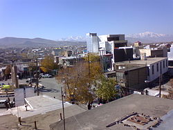
 Central Square of Aligudarz | |
| Coordinates: 33°24′09″N 49°41′25″E / 33.40250°N 49.69028°E[1] | |
| Country | Iran |
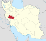
| Province | Lorestan |
| County | Aligudarz |
| District | Central |
| Population (2016)[2] | |
• Total | 89,268 |
| Time zone | UTC+3:30 (IRST) |
| Climate | Csa |
Aligudarz (Persian: اليگودرز)[a] is a city in the Central District of Aligudarz County, Lorestan province, Iran, serving as capital of both the county and the district.[4]
Demographics
[edit]Population
[edit]At the time of the 2006 National Census, the city's population was 78,690 in 18,115 households.[5] The following census in 2011 counted 87,967 people in 23,181 households.[6] The 2016 census measured the population of the city as 89,268 people in 25,646 households.[2]
Geography
[edit]Location
[edit]Aligudarz is located 420 kilometres (260 mi) from Tehran and is in a region that is a mixture of plains and foothills, thus enjoying a mountainous, mild climate. Oshtorankuh Mountain range and Aligudarz River are here.
Climate
[edit]Aligudarz has a dry-summer continental climate (Dsa), bordering on a mediterranean climate (Csa) in Köppen climate classification.[citation needed]
| Climate data for Aligoodarz (1991-2020, extremes 1986-present) | |||||||||||||
|---|---|---|---|---|---|---|---|---|---|---|---|---|---|
| Month | Jan | Feb | Mar | Apr | May | Jun | Jul | Aug | Sep | Oct | Nov | Dec | Year |
| Record high °C (°F) | 16.7 (62.1) |
18.6 (65.5) |
25.2 (77.4) |
28.0 (82.4) |
32.0 (89.6) |
39.4 (102.9) |
41.0 (105.8) |
38.0 (100.4) |
35.0 (95.0) |
30.0 (86.0) |
22.6 (72.7) |
20.0 (68.0) |
41.0 (105.8) |
| Mean daily maximum °C (°F) | 5.0 (41.0) |
7.2 (45.0) |
12.1 (53.8) |
17.3 (63.1) |
23.1 (73.6) |
30.1 (86.2) |
33.7 (92.7) |
33.2 (91.8) |
28.9 (84.0) |
21.7 (71.1) |
13.2 (55.8) |
8.0 (46.4) |
19.5 (67.0) |
| Daily mean °C (°F) | −0.6 (30.9) |
1.6 (34.9) |
6.1 (43.0) |
11.2 (52.2) |
16.4 (61.5) |
22.5 (72.5) |
26.3 (79.3) |
25.7 (78.3) |
21.0 (69.8) |
14.5 (58.1) |
7.1 (44.8) |
2.3 (36.1) |
12.8 (55.1) |
| Mean daily minimum °C (°F) | −5.4 (22.3) |
−3.3 (26.1) |
0.5 (32.9) |
5.1 (41.2) |
9.0 (48.2) |
13.1 (55.6) |
17.4 (63.3) |
17.0 (62.6) |
12.3 (54.1) |
7.4 (45.3) |
1.8 (35.2) |
−2.3 (27.9) |
6.1 (42.9) |
| Record low °C (°F) | −31.0 (−23.8) |
−20.0 (−4.0) |
−17.4 (0.7) |
−7.0 (19.4) |
0.8 (33.4) |
6.4 (43.5) |
10.0 (50.0) |
9.0 (48.2) |
4.6 (40.3) |
−2.0 (28.4) |
−11.8 (10.8) |
−17.6 (0.3) |
−31.0 (−23.8) |
| Average precipitation mm (inches) | 48.3 (1.90) |
48.5 (1.91) |
71.5 (2.81) |
66.9 (2.63) |
25.2 (0.99) |
1.9 (0.07) |
2.0 (0.08) |
0.9 (0.04) |
1.7 (0.07) |
22.5 (0.89) |
51.8 (2.04) |
55.8 (2.20) |
397 (15.63) |
| Average precipitation days (≥ 1.0 mm) | 5.9 | 6.2 | 7.2 | 7.3 | 3.9 | 0.5 | 0.4 | 0.2 | 0.3 | 3 | 5.1 | 6.4 | 46.4 |
| Average rainy days | 4 | 5 | 9.3 | 10.8 | 5.9 | 0.7 | 0.9 | 0.4 | 0.6 | 4.7 | 7.9 | 6.1 | 56.3 |
| Average snowy days | 7.5 | 6.8 | 4.1 | 0.8 | 0.0 | 0.0 | 0.0 | 0.0 | 0.0 | 0.0 | 0.9 | 5.0 | 25.1 |
| Average relative humidity (%) | 62 | 58 | 51 | 47 | 39 | 24 | 21 | 20 | 22 | 35 | 53 | 60 | 41 |
| Average dew point °C (°F) | −7.5 (18.5) |
−6.4 (20.5) |
−4.6 (23.7) |
−1.0 (30.2) |
0.9 (33.6) |
0.1 (32.2) |
1.6 (34.9) |
0.6 (33.1) |
−2.4 (27.7) |
−2.3 (27.9) |
−3.0 (26.6) |
−5.3 (22.5) |
−2.4 (27.6) |
| Mean monthly sunshine hours | 203 | 204 | 231 | 241 | 305 | 354 | 336 | 337 | 319 | 271 | 208 | 195 | 3,204 |
| Source 1: NCEI[7] | |||||||||||||
| Source 2: IRIMO (snow/sleet days 1986-2010 and extremes) [1], meteomanz[8] | |||||||||||||
Main sights
[edit]In the mountains and hills around Aligudarz, ancient objects have been discovered, including rectangular brick earthenware from the thirteenth century AD.
Important natural and historical sites of Aligudarz include:
- Ab Sefid (literally "White Water") waterfall
- Aligudarz Forests
- Sayleh castle
- Tamandar and Bexnavid caves
- Masisilan Ancient Hill
- Mandish mountain
- Chakan Waterfall
- Shoul Abad landscapes
Notable people
[edit]- Mehdi Karroubi, politician
- Morteza Mousavi, Shia Cleric
- Hamed Lak, football player
- Omid, singer
Gallery
[edit]-
Road in vicinity of Aligoudarz at winter.
-
Ab Sefid Waterfall
See also
[edit]Notes
[edit]References
[edit]- ^ OpenStreetMap contributors (30 December 2024). "Aligudarz, Aligudarz County" (Map). OpenStreetMap (in Persian). Retrieved 30 December 2024.
- ^ a b Census of the Islamic Republic of Iran, 1395 (2016): Lorestan Province. amar.org.ir (Report) (in Persian). The Statistical Center of Iran. Archived from the original (Excel) on 12 October 2020. Retrieved 19 December 2022.
- ^ Aligudarz can be found at GEOnet Names Server, at this link, by opening the Advanced Search box, entering "-3052669" in the "Unique Feature Id" form, and clicking on "Search Database".
- ^ Approval of the organization and chain of citizenship of the elements and units of the country divisions of Lorestan province, centered in the city of Khorramabad. lamtakam.com (Report) (in Persian). Ministry of the Interior, Political and Defense Commission of the Government Board. c. 2024 [Approved 21 June 1369]. Proposal 3233.1.5.53; Letter 907-93808; Notification 82816/T121K. Archived from the original on 19 January 2024. Retrieved 19 January 2024 – via Lam ta Kam.
- ^ Census of the Islamic Republic of Iran, 1385 (2006): Lorestan Province. amar.org.ir (Report) (in Persian). The Statistical Center of Iran. Archived from the original (Excel) on 20 September 2011. Retrieved 25 September 2022.
- ^ Census of the Islamic Republic of Iran, 1390 (2011): Lorestan Province. irandataportal.syr.edu (Report) (in Persian). The Statistical Center of Iran. Archived from the original (Excel) on 19 January 2023. Retrieved 19 December 2022 – via Iran Data Portal, Syracuse University.
- ^ "World Meteorological Organization Climate Normals for 1991-2020: Aligudarz" (CSV). ncei.noaa.gov. NOAA. Retrieved 17 March 2024.
WMO number: 40783
- ^ "Aligudarz - Weather data by months". meteomanz. Retrieved 6 July 2024.


